LiDAR (Light Detection and Ranging) is a remote sensing technology that uses laser light pulses to precisely measure distances. A LiDAR scanner emits short laser beams that bounce off objects and return to the sensor – the distance to a given point is calculated based on the return time of each beam. This creates a dense point cloud – a three-dimensional map of the surroundings consisting of thousands of points representing the room’s surfaces. Thanks to this, LiDAR allows for the creation of very accurate, digital 3D models of the scanned space. Importantly, LiDAR sensors work effectively regardless of lighting – even in darkness – because they use infrared light invisible to the eye. LiDAR technology is not new (it is used in geodesy, archaeology, terrain mapping, and even in autonomous vehicles for scanning roads and observing traffic), but only recently has it reached the masses thanks to smartphones.
LiDAR – what is it and how does it work in a smartphone?
Operating principle in mobile devices In mobile devices (like the latest iPhone Pro series), LiDAR takes the form of a small sensor built in next to the camera. It operates on the principle described above – it emits laser pulses and measures their return time, which allows it to calculate the distance to surrounding objects and create a detailed three-dimensional map of the environment. Each reflected pulse generates a point – the collected points form an accurate 3D model of the space (a “point cloud”). This laser rangefinder in a phone enables precise scanning of rooms in real-time. Importantly, LiDAR in a smartphone works in all lighting conditions – unlike a regular camera, it does not need visible light to measure distance, making it effective even in dark rooms.
LiDAR in iPhone vs. regular camera AR Why does the LiDAR scanner in iPhones make such a difference? Standard AR applications using only the camera rely on image recognition algorithms and so-called SLAM (Simultaneous Localization and Mapping) to detect planes – this makes their measurements approximate and dependent on good lighting and contrasting environmental features. In contrast, LiDAR immediately collects real depth data, so it maps the environment faster and more accurately than the camera alone. Apple states that the LiDAR scanner measures distances with an accuracy of about 1 centimeter, which significantly increases measurement precision compared to cameras relying on optical calibration. In practice, this means an iPhone with LiDAR instantly creates a 3D model of the room, whereas a device without LiDAR must first “learn” the space (recognize angles, planes) and often needs extra light. LiDAR also enables functions previously unavailable – e.g., it significantly improves the Measure app, making its readings more reliable. Additionally, the iPhone uses the LiDAR sensor for faster camera autofocus in low light and for advanced AR effects – making augmented reality on a device with LiDAR more stable and realistic.
A smartphone equipped with LiDAR is, therefore, a small laser scanner. All it takes is the right application to turn the phone into a professional measuring tool. An example is the Polish application AdPlan 3D, which uses the iPhone’s built-in LiDAR scanner for instant room measurement. As we will see later, such a solution completely changes the approach to interior surveying – moving away from the pencil, measuring tape, and laser rangefinder in favor of automatic 3D scanning.
Why is LiDAR ideal for interior measurements?
Using LiDAR technology brings numerous benefits to interior measurements, making it an ideal solution for quick and accurate surveying. Here are the most important advantages of laser scanning compared to traditional methods:
- Express measurement without a tape measure: Scanning rooms with LiDAR is many times faster than manually walking around each room with a tape measure or rangefinder. What used to take several hours can now be done in minutes – while obtaining a complete set of dimensions! No need to unfold tapes or take hundreds of notes; just walk around the interior with the phone. For example, the AdPlan 3D app can scan two rooms in about 5 minutes, automatically collecting all necessary data. This time saving also means saving money and the ability to handle more jobs in the same amount of time.
- Edge accuracy and full geometry mapping: LiDAR provides a high-density point cloud, ensuring every nook and cranny of the room is registered. In practice, this means better stability and precision on wall edges, in corners, and with complex room shapes. The laser “sees” what a camera might miss, e.g., uniform, patternless white walls or irregular bends. The scanner also detects deviations from right angles and curves. As the AdPlan manual shows, to scan a room correctly, you just need to approach each corner and key point with the phone – the application will automatically collect the missing dimensions. Irregular shapes or the presence of furniture are not obstacles – modern LiDAR algorithms can adapt to such challenges and fill in the model with missing data. As a result, the digital 3D model of the interior is a very faithful representation of reality, with an accuracy of 1–2 cm, and often even ~1 cm. This eliminates human errors typical of manual measurements and sketches.
From scan to technical documentation One of the greatest advantages of LiDAR technology in measurement applications is the automation of creating technical documentation. In the past, preparing floor plans and layouts required drawing and dimensioning each wall separately – now, many of these actions happen in the background, immediately after the scan.
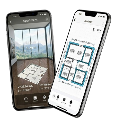
- Automatic 2D floor plans and 3D models. After finishing the room scan, the application (e.g., AdPlan) generates a complete set of drawings. The user receives a classic 2D horizontal projection (floor plan) and wall views with window and door openings marked, as well as a three-dimensional spatial model. All these elements contain full dimensions, so they can serve as technical documentation for further work. Such a model can be immediately used to verify dimensions – e.g., check the dimensions of individual walls or the floor area – and to accurately understand the spatial layout in three dimensions (which can be difficult with 2D visualization alone). In other words, from one scan, we get both a 2D plan and a digital 3D model of the room, ready to use.
- Marking elements and floors. Modern measurement applications can also identify key architectural elements. For example, a 3D scan reveals door and window openings – they can later be marked in the model to be clearly visible on the plans. Some AI-assisted tools even recognize these elements automatically. Furthermore, when surveying larger buildings, multi-floor support is possible. AdPlan allows scanning an entire building floor by floor in one session, separating the data by level. The user can add subsequent floors on the fly, and the application will generate separate plans for each. This way, we obtain complete documentation – from the basement to the roof – without having to merge separate measurements. The resulting 2D plans can serve as accurate technical plans (e.g., for remodeling projects), while the 3D models can be used for visualization or further modeling.
It is worth emphasizing that this entire workflow – from scanning to finished files – takes place automatically and digitally. The user does not need to sketch manually or perform area calculations; the application takes over this role. This is a huge change compared to traditional surveying, where it often took long hours from measurements to drawing plans. Now, the floor plan is created at the same time as we walk around the space with the phone.
Practical applications in industries LiDAR technology in smartphones, supported by applications like AdPlan, finds wide application in various industries related to real estate, construction, and design. Here are examples of how 3D interior scanning improves the work of specialists:
- Energy auditors: When preparing building energy certificates, accurate measurements of partition surfaces (walls, windows, floors) and volume are crucial. Instead of measuring each room manually, an auditor can scan the entire house in minutes and immediately obtain summary surfaces of walls, ceilings, floors, and the building’s volume. Such a digital measurement is not only fast but also reliable – it eliminates the risk of missing a corner. This saves the auditor time (they can prepare the report faster) and allows them to handle more orders, and the results are supported by a detailed 3D model, which increases client trust.
- Property appraisers: When valuing an apartment or house, both time and precision count. A LiDAR scanner allows the appraiser to obtain a complete model of the property with all dimensions in a few minutes. There is no fear that a room will be missed or the area miscalculated – the application will generate an accurate plan of the entire property. The obtained data (e.g., precise usable area) increases the credibility of the valuation, and if necessary, the appraiser has the digital model as evidence to support their calculations. Additionally, a complete measurement record reduces the risk of needing a return visit to the site for missing data.
- Real estate agents: People involved in selling and renting properties appreciate the visual effect and speed of information acquisition. Thanks to LiDAR, an agent can quickly gather the exact area of all rooms during a visit and then present an interactive 3D model of the interior to clients. Such a visualization (e.g., shared online with a buyer) makes a much greater impression than a traditional floor plan. A potential buyer can “walk through” the virtual model, which speeds up the decision and makes the offer more attractive. For the agent, it also saves time – one scan replaces multiple tours for interested parties, while also building a professional image for the agency using modern tools.
- Construction (renovation, building) companies: Crews carrying out renovations or finishing apartments must obtain accurate dimensions at the start to calculate material requirements and cost estimates. LiDAR simplifies this stage – the team scans the interior during the first site visit and gets a ready 3D model with dimensions. Instead of hours spent measuring and drawing rooms, the contractor immediately has precise data for planning work. This means fewer surprises (e.g., wrong paint or tile calculations) and more accurate quotes. Moreover, the 3D model can be taken with them – in the workshop or office, it’s easy to recall the apartment layout, check the height of a niche, etc., which reduces the number of additional site visits. For the construction industry, this is an improvement in the quoting and planning process, translating into time and cost savings.
- Architects and interior designers: Performing a detailed inventory of a room is often the first step in remodeling or interior arrangement. Thanks to LiDAR scanners, an architect can create a base model of the space in minutes instead of drawing it from scratch. The resulting accurate 3D model with dimensions becomes the starting point for design – new partition walls, furniture, or installations can be planned directly within it. Working with verified data reduces errors (e.g., dimensional clashes) at the design stage. What’s more, the ability to present the project in its existing, scanned context facilitates discussion with the client – the investor understands the proposed changes more easily when they see them in a realistic, digital model of their own interior. Additionally, the architect has the building’s existing condition in black and white, which is invaluable when working with historic buildings or unusual objects (every structural detail is documented).
It is worth noting that the examples above are not exhaustive – LiDAR technology is successfully used in other fields as well. On a similar principle, landscape architects can scan terrain before a project, heritage conservators can document complex details of sculptures and facades, and even archaeologists can scan archaeological sites to analyze them as 3D models. However, it is the real estate and construction industries that benefit most from the popularization of laser scanners in smartphones – the precision and speed of interior measurement translate directly into work quality and company competitiveness.
Limitations and best practices Despite many advantages, LiDAR technology also has its limitations. To get the best results when scanning interiors, it’s worth remembering a few good practices and what to avoid:
- Avoid transparent and reflective surfaces: A LiDAR scanner may have difficulty reading very shiny or glass objects. The laser beam can pass through transparent glass or be reflected from a mirror in an unpredictable direction, causing noise in the data or creating a “hole” in the point cloud. Therefore, when scanning, it’s better not to point the phone directly at large mirrors; if possible, cover them or scan them from different angles. Similarly, very glossy furniture or lacquered surfaces can give a false reading. If a room has a lot of glass (e.g., a winter garden) or mirrors, you must accept that the model may require manual completion of these elements.
- Move the device slowly and evenly: Steady scanner movement is key to a complete model. Try to walk with the phone in hand at a calm, smooth pace, making gentle movements with it so that LiDAR has time to capture all the details of the surroundings. Waving the device too quickly can result in scanning errors or missed surface fragments. Most applications (e.g., Polycam, AdPlan) will warn you if you move the phone too fast – it’s worth paying attention to these messages. It’s also good to ensure, if possible, uniform lighting of the scene (even though LiDAR works in the dark, additional light helps the camera register textures and edges, which can improve the final result). If you notice during scanning that an area has not been covered (applications often highlight missing areas in a different color), simply go back there and scan it again up close.
- Verification of key dimensions: Although LiDAR measurements are highly accurate (usually differences <1 cm compared to traditional measurements), it is good practice to check at least one dimension “manually” for certainty. You can, for example, measure the length of a selected wall or the room’s diagonal with a laser rangefinder and compare it with the value in the model. If there is a slight discrepancy (e.g., 1–2 cm over several meters), applications usually allow scaling the model or editing the dimension – it’s worth using such a correction so that the 3D model perfectly matches reality. This single verification acts as a calibration, giving confidence in the precision of the entire scan.
- Order in projects and naming: When scanning multiple rooms or an entire building, take care to organize the data. It’s good to give individual rooms or areas clear names (e.g., Kitchen, Bathroom, Floor 1 – Hall, etc.) within the app. This will make it easier to navigate the generated 2D plans and 3D models later, especially when exporting files for someone else. In reports and plans, the rooms will be described according to your labels, which demonstrates professionalism and reduces the risk of errors. Furthermore, maintain version control – if you do additional scans (supplementary scans), clearly mark them and/or merge them with the main model so that the final result is coherent.
By following the tips above, you can minimize the shortcomings of LiDAR technology and obtain a detailed, accurate model of any interior. Remember that although it is a modern, intelligent tool, it still requires a bit of awareness and care from the user during work – however, the result will be enormous time savings and high data quality compared to traditional methods.
Export and design workflow One of the reasons LiDAR scanning has gained popularity among professionals is the ease with which the measurement results can be used in the further design process. Old measuring devices provided numbers from which drawings still had to be created – today’s applications immediately give us finished files that fit smoothly into the existing workflow.
- Export formats. After finishing the scan and generating the model, the data can be exported to popular file formats with one click. The AdPlan application offers, among others, exporting plans to PDF files and 2D plans and 3D models to DXF, OBJ, and DAE formats. PDF is useful, for example, as a survey report – it contains plans with dimensions and can be immediately handed over to the client or an office. In turn, the DXF file is a universal CAD format: we can open it in AutoCAD or another CAD program to edit the technical drawing, add descriptions, dimension additional elements, or include it in a larger project. OBJ/DAE formats are useful when we want to work on the 3D model – they allow importing the scanned room into environments such as SketchUp, 3ds Max, or Blender. Thanks to this, an architect or interior designer can immediately use the digital model of the room as a basis for design (e.g., insert 3D furniture into it, arrange the space) without the need for laborious modeling from scratch. Integration is usually seamless – the files maintain scale and proportions, and often also the textures or colors registered during the scan.
- Collaboration and further use of data. Digital interior measurements improve communication between all project participants – data can be easily shared with the investor, contractor, or another designer. For example, having an accurate 2D plan in PDF or DXF format, it can be sent to the construction team, who will prepare a quote and action plan based on it. At the same time, the investor can receive an interactive 3D model (e.g., via a web browser or in an app on their phone) to better understand the designed space – what we scanned can easily be published or sent as a file. Such a digital document workflow eliminates problems with unreadable sketches or incorrect interpretations of dimensions. Everyone has the same, accurate model, which reduces the number of questions and misunderstandings. On the construction site, the contractor can look at the model on a tablet instead of shuffling through paper plans. The auditor can attach a printout from AdPlan to their report. What’s more, files can be archived in the cloud – you can return to them at any time or use them for future jobs (e.g., having a model of an apartment, it’s easy to prepare several arrangement variants for subsequent clients).
It is worth adding that tools like AdPlan are created precisely with the intention of fitting smoothly into existing work processes. That’s why exporting to typical formats and integrations (AutoCAD, SketchUp, Blender, etc.) are built into them. For the user, this means that the measurement result is not locked in one application but becomes a universal material for further planning, analysis, and editing. We can treat the scanned interior like any other CAD/BIM project – exchange it, copy elements, apply corrections as work progresses.
Finally, it is worth noting that LiDAR technology in mobile devices, combined with ingenious applications like AdPlan 3D, is democratizing access to advanced measurements. What once required expensive, specialized equipment and expert knowledge is now available at your fingertips – in a smartphone. Traditional surveying ceases to be a tedious task and becomes a fast, autonomous digital process. A modern AR application with LiDAR acts as a personal laser scanner that captures a three-dimensional image of the interior and turns it into a detailed plan. For the construction, architectural, or real estate industries, this is a real revolution – time savings, increased precision, and complete documentation translate into more effective work and better final results. If you haven’t tried such a solution yet, it’s worth doing so – the future of interior measurement is already happening today. Your smartphone equipped with LiDAR can become the most important measuring tool in your work, replacing an entire set of previous instruments. Just launch the application, perform the scan, and see for yourself how LiDAR technology is changing the approach to measuring and planning space.
➡ Try AdPlan today—download it from the App Store and see how easy and accurate interior surveys can be. Turn your phone into a 3D scanner and join satisfied users who’ve saved time and stress with modern measurement technology. Download here: AdPlan – 3D Scanner for Building Measurement, and start planning your spaces precisely and conveniently!